Most people don’t bother with latitude and longitude to identify a location. However, it’s still a sure-fire way to note a location’s exact position when precision is important.
Google Maps lets you find a location and then show its latitude and longitude. You can also enter coordinates directly to find a place. Whether you use the popular maps service on the web or your mobile device, here’s how to use latitude and longitude in Google Maps.
About Latitude and Longitude in Google Maps
Here are a few things to keep in mind when using the GPS coordinates for latitude and longitude in Google Maps:
- Enter the latitude coordinate before the longitude coordinate.
- The first number in the latitude should be between -90 and 90.
- The first number in the longitude should be between -180 and 180.
- Format the coordinates using decimal degrees (36.284065, for example) instead of commas (e.g., 36,284065).
Find the Latitude and Longitude of a Location
You can obtain the latitude and longitude of any location in Google Maps quickly on the web or on your mobile device.
Get Coordinates on the Web
There are a few different ways to get the coordinates on the Google Maps website.
Single-click a location to display a pop-up window at the bottom that shows basic information along with the latitude and longitude. Select any information in the window to open the sidebar on the left, where you can get further details, directions, or add your business.
Right-click a location to display a different pop-up box. This also shows you the coordinates but gives you a way to take a quick action like getting directions, searching nearby, or measuring the distance. You can also copy the coordinates to your clipboard by selecting them in the pop-up menu.
Get Coordinates in the Mobile App
To see the latitude and longitude of a location in the Google Maps mobile app, you’ll simply drop a pin. Open Google Maps and tap or tap and hold to drop a pin.
On Android, you’ll see the coordinates in the Search box at the top. You can swipe up from the bottom for more details and view the latitude and longitude there.
On iPhone, swipe up to display the details at the bottom, and you’ll see the coordinates.
On either device, select the latitude and longitude in the location details at the bottom to place the coordinates on your clipboard.
Search for a Location with Latitude and Longitude
If you obtain the latitude and longitude for a location, you can search for it in Google Maps. Then, use the built-in features to get directions or more details.
Search for a Location on the Web
Enter the coordinates (latitude first) into the Search bar on the top left corner of Google Maps and press the Search button. You’ll then see the location plotted on the map to the right as a red pin with additional location details in the sidebar on the left.
Search for a Location in the Mobile App
Searching for a location using latitude and longitude in the Google Maps app works the same way on Android and iOS.
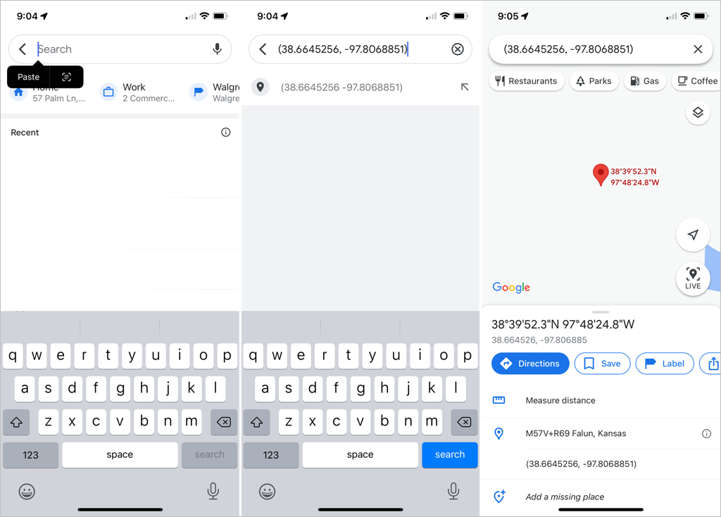
Enter the coordinates into the Search box or tap and choose Paste to insert those you’ve copied to your clipboard. Then, select the Search button on the keyboard to find the location. You’ll see the dropped pin mark the spot.
If you want the exact position of a location, just use latitude and longitude in Google Maps. For more on Google Maps, take a look at how to view your location history or how to see your search history.


